Table of Contents
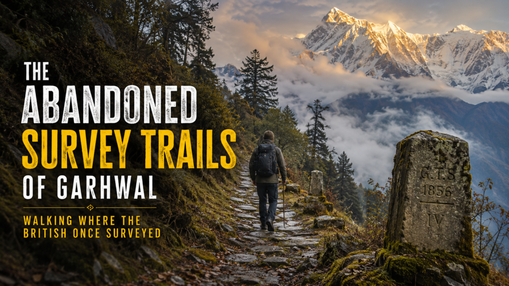
The Abandoned Shikara Trails of Garhwal: Walking Where the British Once Surveyed
If you’ve ever felt that most treks in Uttarakhand start to feel the same — crowded trails, loud music from someone’s Bluetooth speaker, and endless selfies — then the Shikara Trails of Garhwal might be exactly what you’ve been missing.
Last October, I found myself on a narrow, overgrown path above Chakrata. The stones under my boots were cut by hand sometime in the 1840s. A faded milestone, half-hidden by moss, still carried the faint letters “GTS” — Great Trigonometrical Survey. For a moment, the 180 years between me and those British surveyors simply vanished.
These Shikara Trails aren’t on any popular trekking website. They don’t have fancy base camps or Instagram-famous campsites. What they do offer is something increasingly rare in the Himalayas: silence, real history, and the feeling that you’re walking where men once risked everything to measure mountains.
In this guide, I’ll take you through the story of these abandoned British survey trails, the best routes you can still walk in 2026, what you’ll actually discover along the way, and exactly how to plan your own trip without getting in over your head.
The Great Trigonometrical Survey: Measuring the Unmeasurable
Between 1802 and 1871, the British undertook one of the most ambitious scientific projects in history — the Great Trigonometrical Survey of India. The goal was simple on paper but insane in practice: create a scientifically accurate map of the entire subcontinent using triangulation.
In the plains it was difficult. In the Garhwal Himalayas, it bordered on madness.
Survey parties, often consisting of British officers, local Garhwali porters, mathematicians, and “computors,” hauled heavy theodolites up ridges, built signal towers on peaks, and took readings in blinding snow and pouring rain. George Everest himself, the man after whom the world’s highest mountain was eventually named, spent years based in Mussoorie and Dehradun. His old residence, The Park, still stands as a quiet reminder.
The Shikara Trails of Garhwal were born during this period. The name “Shikara” comes from a beautiful blending of meanings. To the British, these were routes to the shikhar (peaks) for surveying. To local hunters, many of the same paths doubled as shikar (hunting) trails. Over time, both communities simply started calling them the Shikara Trails.
These weren’t wide highways. They were carefully chosen ridges and ridgelines that gave clear lines of sight to distant peaks. Many of the paths were improved versions of ancient shepherd routes. After the survey ended and newer roads were built, most of these trails were gradually abandoned. You can still explore the official archives and history on the Survey of India website.
That abandonment is what makes them special today.
What Exactly Are the Shikara Trails of Garhwal?
The Shikara Trails form a loose network of colonial-era paths spread across western Garhwal, particularly around Chakrata, the Mussoorie–Landour ridge, and pockets of the Tons Valley region. Some stretches are still used by a handful of shepherds and forest guards. Others have been reclaimed by forest so completely that you need a local guide who grew up hearing stories about them.
Unlike the famous treks to Kedarnath or Valley of Flowers, these routes see fewer than a few hundred serious walkers each year. That number is unlikely to change much even in 2026, and that’s the point.
You won’t find luxury tents or coffee shops here. What you will find are old milestones, the ruins of small dak bungalows where survey officers once stayed, and views that haven’t changed much since the 19th century. For more context on colonial-era roads and the current state of hill stations, read our guide on the Delhi to Mussoorie Road Trip 2026.
Three Shikara Trails You Can Actually Walk in 2026
Here are the three routes I recommend, ranging from relatively accessible to properly challenging.
1. The Chakrata Ridge Survey Line (Easy to Moderate, 2–3 days)
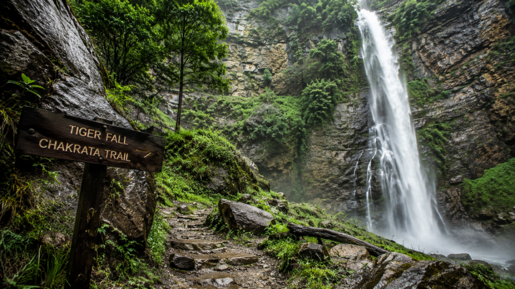
This is the perfect introduction to the Shikara Trails of Garhwal. Starting near Tiger Falls outside Chakrata, the trail follows an old survey alignment along a high ridge.
You’ll pass a remarkably preserved milestone from 1852 and the ruins of a small forest rest house where officers once took astronomical readings. The views of the Bandarpoonch range on clear days are staggering.
Best time: October to mid-November or April to early June.
Difficulty: Suitable for fit beginners with a good guide.
Length: Around 28 km round trip with side explorations.
2. The Landour–Dhanaulti Historical Traverse (Moderate, 4–5 days)
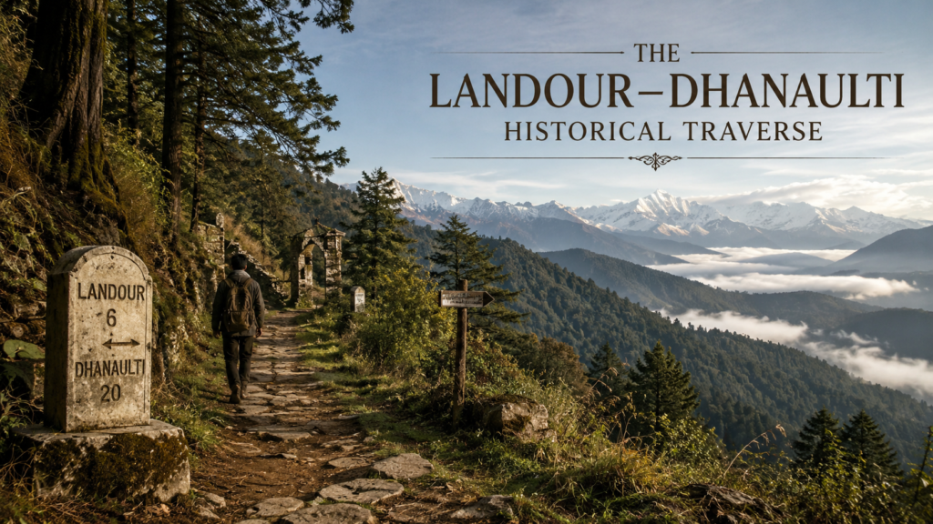
This route connects old triangulation points used during the survey’s push into the inner ranges. It starts from the quiet end of Landour Cantonment (near Everest’s old house) and works its way toward Dhanaulti through thick deodar and oak forests.
The highlight is a clearing where surveyors built a signal tower in the 1830s. You can still see the stone base. Very few people know about this stretch, which is exactly why it feels magical.
This trail also gives you a chance to visit some lesser-known British-era cemeteries where young survey assistants who didn’t survive the harsh conditions are buried. The inscriptions are sobering.
3. The Tons Valley Deep Survey Route (Challenging, 6–8 days)
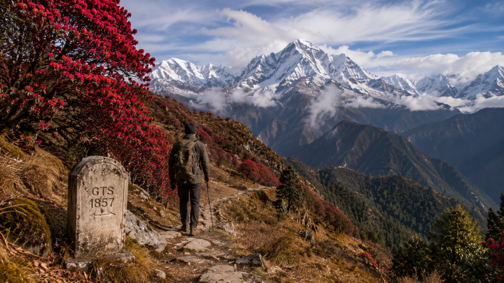
For experienced trekkers, this is the real deal. This Shikara Trail goes much deeper into Garhwal, following one of the original routes survey parties took when trying to triangulate Nanda Devi and its neighbors.
You’ll need a strong local guide from the villages near Mori or Purola. The trail passes through rhododendron forests that turn blood-red in spring, crosses high meadows, and reaches points where the British teams would have had their first clear sight of the snow giants.
This route requires proper permits from the forest department. In 2026, expect tighter checks near the inner line areas. Always cross-check latest requirements on the Uttarakhand Tourism official portal.
Echoes of the Past: What You Actually Find on These Trails
Walking the Shikara Trails of Garhwal feels strangely intimate with history.
You’ll come across:
- Weathered milestones with Roman numerals and dates between 1838 and 1864
- The foundations of old signal towers
- Ruins of dak bungalows with fireplaces still intact
- Occasionally, rusted pieces of equipment that somehow survived decades of monsoons
My guide on the Chakrata route, a quiet man named Balbir from a village near Koti, told me his grandfather used to carry rations for one of the last British survey parties in the 1930s. The stories get passed down.
What hits hardest isn’t always the physical remnants. It’s the silence. Standing on a ridge where a surveyor once spent three weeks waiting for clear weather to take a reading, you suddenly understand how small we are.
The forests here feel different too — older, somehow watchful. In October the oak leaves turn golden and carpet the trail. In spring, the rhododendrons explode in color exactly as they would have for those British officers homesick for England.
For those who love high-altitude and lesser-known routes, these trails complement the experiences shared in our article on 6 Best High-Altitude Trekking Routes in Uttarakhand.
Practical Guide: How to Trek the Shikara Trails in 2026
These aren’t trails you casually wander onto. Here’s exactly what you need to know.
Best Season:
- Autumn (mid-September to mid-November) offers the clearest views and driest trails.
- Spring (April–June) brings rhododendrons but also more rain risk after mid-May.
Getting There:
Dehradun is your gateway. Chakrata is now better connected thanks to improved roads completed in 2024–25. You can reach the starting points by taxi or shared Sumo from Dehradun in 3–4 hours. Our detailed Delhi to Mussoorie Road Trip 2026 guide covers similar road conditions in the region.
Guides and Permits:
Do not attempt these Shikara Trails without a local guide. The paths disappear in places. I strongly recommend guides from villages actually connected to these routes — they know the history as well as the terrain. Expect to pay ₹1,800–2,500 per day for a good guide plus porter support.
Forest permits are usually required for the deeper routes. Your guide can arrange these. As of early 2026, the system is still mostly offline, so don’t expect to do it online.
What to Pack & Budget Tips:
Pack lighter than you think but smarter. Bring good rain gear even in autumn — mountain weather changes fast. A small pair of binoculars helps spot distant peaks the surveyors would have targeted. I also always carry printed sections of old Survey of India maps. There’s something special about comparing the 19th-century map with what you’re seeing.
These trails are perfect examples of the kind of authentic, under-the-radar experiences discussed in What Travelers Don’t Tell You About Uttarakhand.
Safety Notes:
These abandoned British trails are remote. Tell someone reliable your exact route. Leopards are present though rarely seen. Carry a basic first-aid kit and know how to use it. Mobile network is patchy to non-existent on most stretches — that’s part of the appeal. If you’re planning weekend or short treks, also check our guide on 8 Stunning Weekend Treks Near Dehradun.
Why the Shikara Trails of Garhwal Matter in 2026
In an era where even “offbeat” treks are getting crowded, these abandoned survey trails offer something different. They aren’t about reaching a famous destination or ticking off a bucket list temple. They’re about the journey and the stories hidden in the land itself.
Every time I walk these paths, I’m reminded that the Himalayas were mapped by human courage and ingenuity long before satellites and GPS. There’s humility in that.
Supporting responsible travel on the Shikara Trails of Garhwal also helps the small villages along the routes. The money goes directly to families who have guarded this knowledge for generations. This aligns closely with the practical wisdom shared in our recent piece on Kedarnath Yatra Mistakes to Avoid.
Final Thoughts
The Shikara Trails of Garhwal probably won’t become the next big thing in Uttarakhand tourism — and that’s precisely why they’re worth protecting.
If you’re the kind of traveler who finds peace in history, who values silence over convenience, and who wants to walk where very few people have walked in the last fifty years, these abandoned British survey trails are waiting.
Just remember: take only photographs, leave only footprints, and treat the mountains — and their stories — with respect.
The men who first surveyed these routes did it with brass instruments and sheer determination. The least we can do is walk their paths with open hearts and quiet feet.
Frequently Asked Questions
Are the Shikara Trails of Garhwal safe for solo travelers?
The easier sections can be done with a guide if you have experience. I don’t recommend the deeper routes completely solo. Always prioritize local knowledge and preparation.
Do I need any special permits for these British survey trails?
For the Chakrata area routes, usually just basic forest entry. Deeper trails toward the Tons Valley require inner line area permissions. A good local guide makes this process smooth. Latest updates are often posted on the Uttarakhand Tourism portal.
How do these trails compare to popular treks like Kedarnath?
They are significantly quieter, more historical, and generally less crowded. The difficulty is comparable on the harder routes, but the experience is completely different.
Can beginners attempt any of the Shikara Trails?
Yes — the Chakrata Ridge route is suitable for fit beginners with a good guide. The others require previous trekking experience. Our guide on easy to moderate treks can help you build up to these.
What is the best month to trek the Shikara Trails of Garhwal in 2026?
October offers the perfect combination of clear weather, good visibility, and comfortable temperatures. Avoid July–August due to heavy monsoon landslides on these old routes.
Related Articles on uttarakhand.tours:
- 6 Best High-Altitude Trekking Routes in Uttarakhand
- 8 Stunning Weekend Treks Near Dehradun (2026 Guide)
- Delhi to Mussoorie Road Trip 2026: Routes, Costs & Insider Tips
- What Travelers Don’t Tell You About Uttarakhand
- Auli in Summer 2026: 10 Reasons Beyond Skiing
Have you walked any of the old British trails in Uttarakhand? Share your experience in the comments. If you’re planning your own trip on the Shikara Trails of Garhwal, feel free to reach out — I’m happy to suggest reliable guides I’ve worked with.