Table of Contents
Char Dham Yatra 2026: A Complete Guide to Uttarakhand’s Holy Pilgrimage
Last Updated: June 7, 2026
The Char Dham Yatra is not a tourist circuit. It is a pilgrimage that millions of Hindus consider the spiritual summit of their lives — a journey to four abodes in the Garhwal Himalayas that Adi Shankaracharya established in the 8th century as the axis of Hindu worship in India.
I have completed this yatra three times: once by road and foot in 2019, once by helicopter in 2022, and once again in 2024 to document the new infrastructure changes that have transformed the route. This guide is written from those experiences, from conversations with priests and pony operators, and from the practical realities of traveling at altitudes where oxygen thins and weather changes in minutes.
The Char Dham Yatra of Uttarakhand, also known as the Chota Char Dham, is a highly sacred circuit in Hinduism, visited by millions of devotees seeking a lifetime experience of witnessing the beauty of the Garhwal Himalayas. Conducted in the tradition of the arghya from west to east, this divine sojourn, founded by the 8th-century philosopher Adi Shankaracharya, is believed to wash away sins, bestow divine blessings, and effect salvation (Moksha).
Whether you are a pilgrim seeking moksha or a traveler trying to understand why this journey matters, this guide will tell you what you actually need to know — not the brochure version.
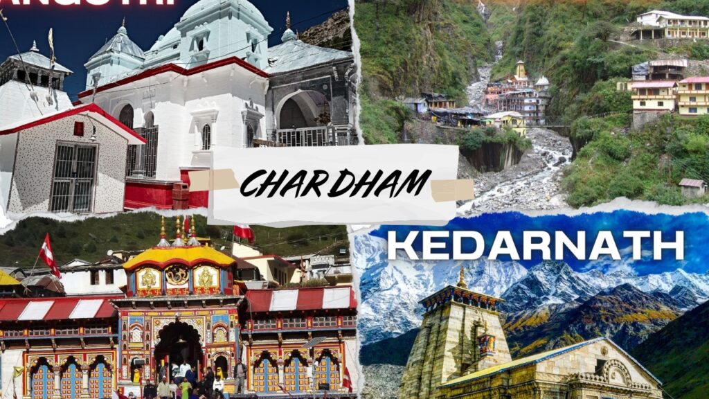
What is the Char Dham Yatra?
The Char Dham Yatra covers four temples in the Garhwal region of Uttarakhand:
- Yamunotri (3,293 meters) — Source of the Yamuna River, dedicated to Goddess Yamuna
- Gangotri (3,100 meters) — Source of the Ganges, dedicated to Goddess Ganga
- Kedarnath (3,583 meters) — One of the 12 Jyotirlingas, dedicated to Lord Shiva
- Badrinath (3,133 meters) — Dedicated to Lord Vishnu as Badri Narayan
The traditional sequence follows the parikrama direction: west to east, beginning at Yamunotri, proceeding to Gangotri, then Kedarnath, and ending at Badrinath. This is not arbitrary — it follows the flow of the rivers and the logic of Himalayan geography.
The yatra season runs from late April/early May to October/November, depending on weather and the Hindu calendar. The temples close for winter when snow makes the upper reaches impassable.
Char Dham Yatra 2026: Opening and Closing Dates
The 2026 Char Dham Yatra is currently active. Based on the official announcements by the Uttarakhand government and the temple committees:
- Yamunotri Temple: Opened April 29, 2026 (Akshaya Tritiya)
- Gangotri Temple: Opened April 29, 2026 (Akshaya Tritiya)
- Kedarnath Temple: Opened May 1, 2026
- Badrinath Temple: Opened May 3, 2026
Closing dates (tentative, based on the Hindu calendar):
- Badrinath: November 8, 2026 (Vijayadashami)
- Kedarnath: November 3, 2026
- Yamunotri and Gangotri: October 31 / November 1, 2026
Always verify closing dates on the official Uttarakhand Tourism website (uttarakhandtourism.gov.in) before traveling, as weather can force early closures.
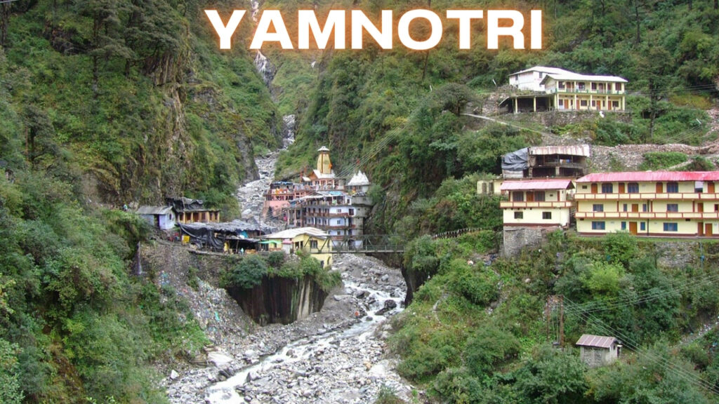
1. Yamunotri: Where the Yamuna Begins
Overview
Location: Uttarkashi district, Garhwal Himalayas
Elevation: 3,293 meters
Temple timings: 6:15 AM – 2:00 PM, 3:00 PM – 9:30 PM
The Real Experience
Yamunotri is the most physically demanding of the four Dhams, not because of altitude, but because the final 6 kilometers from Janki Chatti must be covered on foot, by pony, or by palanquin. The trek is steep, the air is thinner than you expect, and the trail is often crowded with pilgrims moving at different speeds.
When I did this trek in May 2024, I started at 5:30 AM from Janki Chatti to avoid the midday heat and the afternoon pony traffic. The trail follows the Yamuna upstream through dense forest. About 2 kilometers in, the vegetation thins and the valley opens up. By kilometer 4, you are walking on loose rock and the sound of the river becomes a constant roar.
The temple itself is small — a black marble structure built in the 19th century by Maharani Guleria of Jaipur. Behind it, the actual source of the Yamuna is a thermal spring called Surya Kund, where the water temperature stays near boiling. Pilgrims tie rice and potatoes in cloth and lower them into the spring to cook as prasad. This is not symbolic — the water is literally hot enough to cook food in minutes.
Divya Shila, a rock pillar near the temple, is worshipped before entering the main shrine. Do not skip this — the priests are particular about the sequence of rituals.
How to Reach Yamunotri
By Road:
- Haridwar/Rishikesh to Barkot: 215 km, 5–6 hours by taxi or bus
- Barkot to Janki Chatti: 45 km, 2 hours by jeep (shared jeeps available, Rs. 100–150 per seat)
- Janki Chatti to Yamunotri Temple: 6 km trek (4–5 hours on foot), or pony/palanquin (Rs. 1,200–2,500 one way, rates fixed by the pony union)
By Helicopter:
- Dehradun (Sahastradhara Helipad) to Kharsali Helipad, followed by a 5.3 km trek or pony ride to the temple
- Helicopter bookings: heliyatra.in or through authorized operators (Rs. 25,000–40,000 for the full circuit, depending on package)
Nearest Airport: Jolly Grant, Dehradun (185 km from Barkot)
Nearest Railway Station: Haridwar or Rishikesh
Where to Stay
- Janki Chatti: Budget lodges and GMVN rest house (Rs. 800–2,000/night). Book GMVN in advance at gmvnl.com.
- Barkot: More options, including private hotels (Rs. 1,500–3,500/night). Better for acclimatization.
Pro tip: Do not attempt to reach Yamunotri and return to Barkot in one day unless you are physically fit. The altitude gain is significant and altitude sickness is common among those who rush.
Nearby Places to Visit
Hanuman Chatti
It is one of the beginning points of the trek that leads to two important places—Yamunotri and Dodi Tal. Yamunotri is only 13 km away from Hanuman Chatti, which can be easily covered by foot or on ponies. One can also find jeeps to Janki Chatti, which is only 6 km away from Hanuman Chatti. Hanuman Chatti is the meeting point of Yamuna and Ganga River. One can also find food items and raincoats from Hanuman Chatti.
Barkot
Situated at an elevation of 1,220 meters above sea level in the district of Uttarkashi, Barkot is one of the most important destinations to choose for excursion in the state of Uttarakhand. The place provides comfortable accommodation facilities and ensures easy stay after hectic travelling schedules. Besides the recreational value that this place has to offer, Barkot also has an ancient temple that is situated 49 km distance from Yamunotri.
Dodi Tal
As per Indian Mythology, Dodi Tal is the birthplace for Lord Ganesh and has a beautiful Ganesha Temple crafted along the banks of this lake. Dodi Tal is a freshwater lake that is situated at an elevation of 3,307 meters above sea level and is besieged with dense forest of rhododendrons, oak, and deodar. This lake is also called a mysterious lake as its depth cannot be measured till day. Dodi is home to endangered Himalayan Golden Trouts and many other rare species of fishes. Dodi Tal offers wonderful splendid sites and is a famous trekking spot.
Uttarkashi
Positioned at a raised level of 1,352 meters above sea level, Uttarkashi is a famous tourist spot. It is 78 km away from Hanuman Chatti and offers a picturesque view to travelers. The place is well connected by motorable roads and is a famous destination of the Uttarakhand state. Along the banks of River Bhagirathi, Uttarkashi offers a wonderful glimpse to serene environ and gushing water. Moreover, trekking interest in people here and around the world has led to construction of the reputed institute of Mountaineering—Nehru Institute of Mountaineering that offers training courses in trekking, climbing, and mountaineering.
Janki Chatti
On the way to trek to Yamunotri, Janki Chatti is the midpoint that can be easily reached by jeeps. It is situated at a mere distance of 7 km afore Yamunotri and is a renowned place for thermal springs. Many visitors stop by Janki Chatti to enjoy the sightseeing here and wash their sins in thermal springs.
Surya Kund
Amid several natural thermal springs in Yamunotri, Surya Kund is the most famous one. It is astonishing, but the water temperature of Surya Kund remains 190°F. Many pilgrims tie potatoes and rice to cook it by immersing it under the water of Surya Kund. After this, it is served as prasad. So, religious value attached to the place is high, but besides, there are many wonderful sights to lush green nature and extensive ranges that follow you all the way to Yamunotri.
Divya Shila
Divya Shila is a rock pillar that is situated outside the Yamunotri temple and is worshipped by Hindu pilgrims.
Tips for Yamunotri
- Bring warm clothes, good trekking shoes, and a walking stick for the hike.
- Get used to the high altitude to prevent altitude sickness.
- Book a place to stay in advance in Barkot or Janki Chatti, especially in peak season.
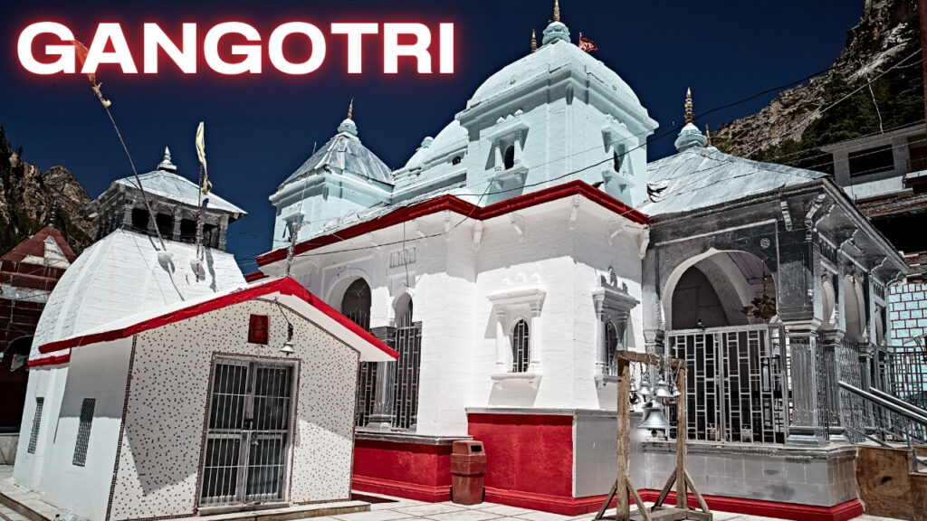
2. Gangotri: The Ganga’s True Source
Overview
Location: Uttarkashi district, on the banks of the Bhagirathi
Elevation: 3,100 meters
Temple timings: 6:15 AM – 2:00 PM, 3:00 PM – 9:30 PM
The Real Experience
Unlike Yamunotri, Gangotri is accessible by motorable road. The temple sits in a valley of deodar and pine, with the Bhagirathi River rushing past it. The air here feels different — colder, cleaner, and filled with the sound of water.
The temple was built by the Gurkha general Amar Singh Thapa in the early 19th century. It is white, modest, and surrounded by a stone courtyard where pilgrims sit to warm themselves in the sun. The evening aarti at 7:30 PM is worth attending — the priests chant with the river as background noise, and the lamps reflect on the water.
The actual source of the Ganga is not at Gangotri. It is at Gaumukh, 18 kilometers upstream, where the glacier melts into a stream. I trekked to Gaumukh in 2019 with a permit from the Gangotri National Park office (permits are mandatory and checked at Chirbasa). The trek is not difficult but it is long — plan for two days with a night at Bhojbasa.
Submerged Shivling, a natural rock formation in the river near the temple, is visible during winter when water levels drop. In summer, it is mostly underwater.
How to Reach Gangotri
By Road:
- Haridwar/Rishikesh to Uttarkashi: 175 km, 5–6 hours
- Uttarkashi to Gangotri: 100 km, 3–4 hours. The road is narrow but entirely motorable.
- Total from Haridwar: approximately 275 km, 9–10 hours of driving. Most pilgrims break the journey at Uttarkashi.
By Helicopter:
- Harshil Civil Helipad (near Gangotri) receives helicopter services from Dehradun and Kharsali. From Harshil, Gangotri is 23 km by road.
Nearest Airport: Jolly Grant, Dehradun (250 km)
Nearest Railway Station: Haridwar or Rishikesh
Where to Stay
- Gangotri: GMVN rest house, ashrams, and budget lodges (Rs. 800–2,500/night). The GMVN TRH is the most reliable option.
- Harsil (21 km before Gangotri): A beautiful riverside village with better accommodation options, including the Harsil Retreat (Rs. 3,000–5,000/night). Worth staying here and doing a day trip to Gangotri.
- Uttarkashi: Full range of hotels if you prefer to stay lower (Rs. 1,000–4,000/night).
Nearby Places to Visit
Uttarkashi
Positioned at an elevation of 1,352 meters above sea level, Uttarkashi is a place 93 km away from Gangotri and is a charming must-to-explore destination. Uttarkashi is strongly connected via roads and provides a smooth and swift traveling experience to all important destinations of Uttarakhand. On the banks of the holy river Bhagirathi, Uttarkashi doles out a splendid view. Furthermore, the National Institute for Mountaineering is also situated here, which offers various training courses in mountaineering and climbing.
Dodital
This freshwater lake is one of the finest sites around Gangotri. The lake flows at a height of 3,037 meters above sea level and is surrounded by dense forest of deodar, oak, and rhododendrons. It is said that Lord Ganesha was born on the banks of this lake. The depth of this lake is still a mystery. In addition, the beginning point of the 18-km-long trek of Dodital trek is Agoda. The entire trekking remains a fun-filled experience with beautiful sites to explore en route.
Kedartal
The way to Kedartal involves difficult trekking of 14 km that commences from Gangotri. The best about Kedartal is its clean and clear waters that mirror the reflection of snow-laden Himalayan peaks. En route to Kedartal trekking, the maximum height one may encounter is astounding, i.e., 4,219 meters. The lake flows at a height of 4,225 meters above sea level with magnificent Thalay Sagar running alongside, doling out an impeccable experience.
Gangnani
On the way to Gangotri, 47 km before, is a place known as Gangnani. It is known for its thermal spring. People bathe in the thermal spring to wash away their sins afore heading for Gangotri.
Harsil
Having plentiful scope for natural beauty, Harsil is an emerald of Uttarakhand. It is a perfect destination for adventure lovers. Harsil is located on the banks of river Bhagirathi and is 2,620 meters above sea level. The total distance from Gangotri to Harsil is 21 km. One can plan for an easy and short trek from Harsil to Shattal.
Tapovan
From Gaumukh Glacier, one can go ahead to explore Tapovan and Nandvan. It is suggested to hire a trekker here as it might get difficult for seasonal trekkers to cross the path sometimes. The trekking path from here is rock-strewn and can be a tedious affair at times. From Tapovan, tourists get a chance to sightsee amazing vistas and Garhwal Himalayas.
Bhairon Ghati
In the vicinity of the confluence of Jat Ganga and Bhagirathi River lies the beautiful Bhairon Ghati. The Ghati is located 10 km away from Gangotri. The place is famous for Lord Bhairav Nath temple that is situated here. The area around is surrounded by thick and dense forest. Bhairav Nath temple can be reached by traveling from Lanka to Bhairon Ghati via road and further by crossing the Jhanvi River.
Submerged Shivling
In the lap of Goddess Ganga sits the naturally made idol of Lord Shiva. The Shivling remains submerged during all the months and is visible only during winters when the water level decreases. As per old sayings, it is believed that Goddess Ganga and Lord Shiva have ascended in his matted locks here.
Tips for Gangotri
- Bring rainwear, as the area is known for surprise rain showers.
- Observe local customs, dress respectfully, and avoid littering.
- If you are up for treks to Gomukh or any other secluded area, engage a local guide.
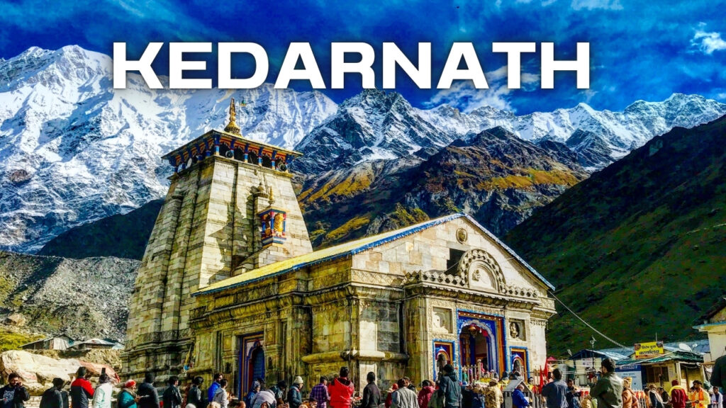
3. Kedarnath: The Highest Jyotirlinga
Overview
Location: Rudraprayag district
Elevation: 3,583 meters
Temple timings: 4:00 AM – 3:00 PM, 5:00 PM – 9:00 PM
The Real Experience
Kedarnath is the emotional center of the Char Dham Yatra. It is also the most challenging to reach. The 16-kilometer trek from Gaurikund climbs steadily through rocky terrain, crossing waterfalls, landslide zones, and sections where the trail is barely wide enough for two people to pass.
I walked this in September 2024, after the monsoon rush had subsided. Even then, the trail was crowded. Ponies and palanquins create constant traffic. The altitude hits you around kilometer 10 — headache, shortness of breath, nausea. I saw a man in his 40s being carried down by a rescue team because he ignored the symptoms.
The temple is built from massive grey stone slabs, designed to withstand Himalayan winters. Behind it, the Kedarnath peak rises like a sentinel. The first sight of the temple after the final bend of the trail — the shikhara against snow-covered mountains — is why people endure the trek.
The new infrastructure is significant. Since the 2013 floods, the trail has been widened, bridges reinforced, and medical stations added at Linchauli and Bheembali. But the mountain has not become safe. Weather can still turn in minutes.
How to Reach Kedarnath
By Road and Trek:
- Haridwar/Rishikesh to Guptkashi: 200 km, 7–8 hours
- Guptkashi to Gaurikund: 32 km, 1.5 hours
- Gaurikund to Kedarnath Temple: 16 km trek (5–7 hours on foot), or pony/palanquin (Rs. 2,500–4,000 one way)
By Helicopter:
- Phata Helipad to Kedarnath Helipad: 8–10 minutes. The helipad is 500 meters from the temple.
- Helicopter bookings: Book through heliyatra.in or IRCTC’s helicopter booking portal. One-way fare: Rs. 4,500–7,000 per person (prices vary by operator and demand). Full Char Dham helicopter packages from Dehradun cost Rs. 1,75,000–2,25,000 per person for 4–5 days.
Nearest Airport: Jolly Grant, Dehradun (230 km from Gaurikund)
Nearest Railway Station: Haridwar or Rishikesh
Where to Stay
- Kedarnath: Limited accommodation. GMVN TRH, Punjab Sindh Awas, and basic lodges (Rs. 1,000–3,000/night). Book well in advance for May–June.
- Gaurikund: More options at the base (Rs. 1,500–3,000/night), but you will need to start the trek early morning.
- Guptkashi/Sonprayag: Better hotels, often used by helicopter passengers (Rs. 2,000–5,000/night).
Critical Safety Note: The 2024 season saw multiple days when the trek was suspended due to heavy rain and cloudbursts. Always check the weather forecast at the Gaurikund registration counter before starting. Do not trek in rain — the trail becomes a stream, and landslide risk is real.
Nearby Places to Visit
Kedarnath Temple
The name of Kedarnath temple comes amongst the holiest pilgrimage centers of India. This temple is dedicated to Lord Shiva and comes amongst the Char Dhams of India. The temple is situated at an elevation of 3,584 meters above sea level in the surroundings of the great Himalayas. According to mythology, Pandavas wanted to come out from the entire sin they did during the Mahabharata war at this place. But Lord Shiva was extremely angry with them and had converted himself into the form of a bull and dug himself under the ground. Thus, this place contains more religious importance and is known as a Char Dham of India.
Vasuki Tal
Vasuki Tal is located only 7 km away from Kedarnath, and you can reach this place by a simple trek. You’ll find this lake at an elevation of 4,150 meters above sea level along with the boundary of the great Himalayan peaks.
Gaurikund
Gaurikund is located at an elevation of more than 6,000 feet above sea level and is the base camp for the trek to Kedarnath. The place Gaurikund is dedicated to Goddess Parvati (wife of Lord Shiva), and the story of this place is also associated with Lord Ganesha. This place is situated amidst lush green forest, providing serene environments and memorable views.
Shankaracharya Samadhi
Everyone knows Shankaracharya, who established the Char Dhams of India, those that are still the holiest pilgrimage centers. He went to his Samadhi at an early age of 32, and thus this place contains massive religious significance.
Kalimath
Kalimath is basically an ancient temple and one amongst the ‘Seedha Peeth,’ holding matchless religious importance, and due to this, a massive crowd of devotees can be found at this place throughout the year. Kalimath is also called Kaviltha, and it’s basically a divine village. You’ll find this place at an elevation of almost 6,000 feet above sea level and belongs to the Rudraprayag district of Uttarakhand. This temple was established by Adi Shankaracharya.
Ukhimath
Ukhimath is a well-known tourist destination of India and is situated at an elevation of 1,311 meters above sea level. During winters, the place has more religious significance as this is assumed to be the home of Lord Shiva and Madhyamaheswar. Due to this, you can experience an amazing crowd at this place during winter.
Chopta
Due to exceptional natural beauty and sightseeing, Chopta is acknowledged as the mini Switzerland of Uttarakhand. In recent years, Chopta has become the leading vacation spot, and the number of visitors is increasing at an outstanding rate. Tungnath is known as the highest temple of Uttarakhand, situated and located only at a distance of 3.5 km from Chopta.
Rudraprayag
Rudraprayag is the major city of Uttarakhand and known for its beauty and religious significance. It is located at the convergence point of the river Alaknanda and Mandakini. Rudraprayag is situated at a very short distance from Kedarnath, i.e., 80 km only. The place is named based on the name of Lord Shiva, as Rudra is the 108th name of Lord Shiva.
Trijuginarayan Temple
The place is the evidence of the marriage of Lord Shiva and Goddess Parvati. You’ll find an immortal flame that is still burning around the place where the marriage of Lord Shiva was held with Goddess Parvati.
Tips for Kedarnath
- Get into shape for the hike; it’s tough at high altitude, so train yourself beforehand.
- Bring first aid supplies, medication, and oxygen bottles for altitude sickness.
- Helicopter tickets must be booked well in advance since they are always in demand, especially during peak season (check HeliYatra).
Badrinath: The Final Dham
Overview
Location: Chamoli district, on the banks of the Alaknanda
Elevation: 3,133 meters
Temple timings: 4:30 AM – 1:00 PM, 4:00 PM – 9:00 PM
The Real Experience
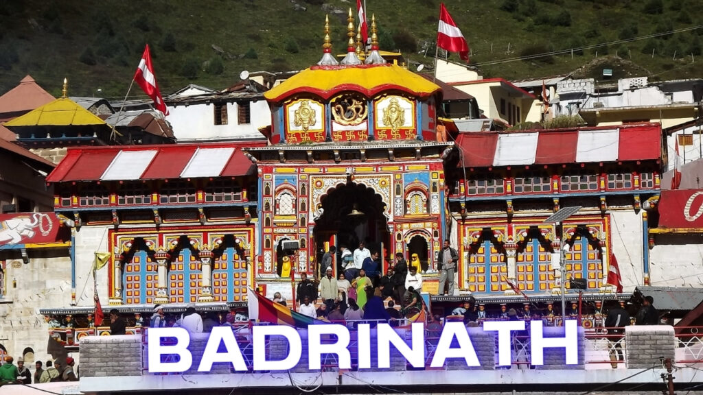
Badrinath is the most accessible of the four Dhams and, in many ways, the most grand. The temple is a bright orange and yellow structure, vividly painted against the grey-brown mountains. The Alaknanda flows fast and cold beside it. The entire town feels like a settlement built for one purpose — worship.
Before entering the temple, pilgrims bathe in Tapt Kund, a natural hot water spring that maintains a temperature of 45°C even when the air outside is near freezing. The contrast between the hot water and cold air is shocking. The kund is also the source of the temple’s water supply — there is no municipal plumbing at this altitude.
The aarti at 4:30 AM (Mahabhishek) is the main event. If you want to attend, queue by 3:30 AM. I did this in October 2024 and the line was already 200 meters long. The temple opens to the public after the morning rituals, but special darshan tickets (Rs. 300) allow faster entry.
Mana Village, 3 kilometers from the temple, is the last inhabited village before the Tibet border. It is also where the Saraswati River meets the Alaknanda. The village has become a tourist stop, but it is still worth visiting for Vyas Gufa and Ganesh Gufa — the caves where the Mahabharata is said to have been composed.
How to Reach Badrinath
By Road:
- Haridwar/Rishikesh to Joshimath: 275 km, 8–9 hours
- Joshimath to Badrinath: 45 km, 1.5–2 hours
- Total from Haridwar: approximately 320 km
By Helicopter:
- Badrinath Helipad is 1 km from the temple. Helicopter services operate from Dehradun and Phata.
Nearest Airport: Jolly Grant, Dehradun (310 km)
Nearest Railway Station: Haridwar or Rishikesh
Where to Stay
- Badrinath: GMVN TRH, Panchayat guest houses, and private hotels (Rs. 1,500–5,000/night). The New GMVN TRH is the best government option.
- Joshimath: More variety and better value if you do not mind the 45 km drive each day (Rs. 2,000–6,000/night). Joshimath is also the winter seat of Lord Badrinath (Vasudeva Temple).
Nearby Places to Visit
Badrinath Temple
Badrinath Temple is one of the most sacred temples in Badrinath District. Situated on the banks of Alaknanda River, surrounded by Nar Parvat, Badrinath Temple is dedicated to Lord Vishnu. The temple was established by saint philosopher Adi Shankaracharya in the 8th century and holds a small cupola of gilt bull and spire and is built in the shape of a cone.
The Badrinath temple is well known for its Badrinath deity sculpted in black stone, which is around one meter large and represents Lord Vishnu seated in a contemplative pose. The main entrance gate of Badrinath temple is called “Singh Dwara,” which is a major center of attraction of the temple.
Besides this, the temple has stunning 15 idols of different Hindu gods. Millions of domestic as well as foreign travelers and devotees visit this holy place every year from May to October. During the winter, the temple remains closed because of heavy snowfall.
Tapt Kund
Tapt Kund is a natural thermal spring and considered the dwelling of Lord Agni, where one has to take a sacred dip. The dip into Tapt Kund is very important before going to the temple and is also believed to spiritually revitalize and cleanse all sins. All the followers and tourists take a holy dip in Tapt Kund together without even knowing each other. The expected temperature of the water of Tapt Kund is 45°C. This holy place is a worth-watching destination.
Brahma Kapal
Brahma Kapal is a place located on the banks of River Alaknanda and is placed in the region of Badrinath Temple. It is believed that at this place Lord Brahma resides, and it is also believed that the head of Lord Brahma had fallen off in Brahma Kapal Ghat. Hindu devotees perform various rituals and prayers to the dead ancestors and also offer shraddha to their intimates.
Neelkanth
Neelkanth, which is also tagged as “Garhwal Queen,” is named after God Shiva, who is also called Neelkanth. It is a snowy peak located above Badrinath temple in the shape of a pyramid. Neelkanth peak is located at an altitude of 6,597 meters above sea level. It is a beautiful site where the sun spreads its first ray. Numerous travelers can also come across various Brahmakamals, which can be viewed at the foot of the Neelkanth Peak. Furthermore, tourists can also cover 6 kilometers of trekking route easily on this peak.
Mata Murti Temple
Located at a distance of 3 kilometers from Badrinath, Mata Murti Temple is a famous holy temple dedicated to the mother of Lord Narayan. According to a myth, Mata Murti worshipped God Vishnu to take his next birth as her son, and after blissfully agreeing with that, Lord Vishnu came into the world as twins, Narayana and Nara, to kill a giant. There is an admired faith that the goddess has the power of conceding Vairagya to those who meditate honestly in her presence. Every year, a fair is organized in the land of Mata Murti Temple, where the mother of Shri Badrinath is worshipped.
Charanpaduka
Located at a distance of 3 kilometers from Badrinath Temple, Charanpaduka is a famous rock as it possesses the footprints of Lord Vishnu. This temple falls on a lovely meadow covered with diverse wildflowers in the summers. There is a belief that an honest visit to this sacred place will retrieve you from ailments and other troubles. There are numerous caves and rocks on the way that direct to Charanpaduka. This path will also lead you to the bottom of Neelkanth peak, where you can see numerous Brahmakamals.
Narad Kund
Situated nearby Tapt Kund, Narad Kund is one of the sacred places in Badrinath after the name of Badrinath Temple. It is the place where the deity of Lord Vishnu was recovered by Adi Guru Shankara. It is assumed that the name of Narad Kund was given after Saint Narada Muni, who wrote Narada Bhakti Sutra at this spot. Narad Kund is visited to take a sacred dip into the holy water before visiting the temples. Besides this, there are many other natural hot water springs situated.
Satopanth
Situated at a distance of 25 km from Badrinath and set up above 4,402 meters above sea level, Satopanth is a triangular-shaped lake with three corners extending inside the circumference of about a kilometer. It is enclosed by heavy snow-covered peaks and is named after the Hindu Lords Vishnu, Mahesh, and Brahma. There is a belief that these three gods inhabit one corner each of the Satopanth Lake.
Mana
Located at a distance of 3 kilometers from Badrinath, Mana is very near to the Tibet border and is one of the last villages of our country. It is occupied by Indo-Mongolian tribes, often referred to as Bhotias. Most of the travelers who visit Badrinath also come to glimpse the end of the road at Mana.
Bheem Pul
Located opposite to the Vyas Gufa in Mana Village, Bheem Pul is an exciting and adventurous tourist place. It is believed that this is the place where Bheem (one of the five Pandava brothers) threw a huge rock to make a path joining the two mountains so that Draupadi could easily walk over it. Below this mountain, the Saraswati River flows with force and joins the Alaknanda River.
Sheshnetre
Located at a distance of 1.5 km from Badrinath, Sheshnetra is one of the famous holy sites. This is a big massif stone that is distinct with an eye of a renowned snake. It is said that Lord Vishnu took leave on an enormous snake called Ananta Shesha. This holy place has natural marks on the rock. There is a popular belief that Sheshnetra protects the sanctified temple of Lord Badrinath.
Vyas Cave
Vyas Gufa or Vyas Cave is a popular place from where Ved Vyas stated the entire Mahabharata to Lord Ganesha so that he could write. Ved Vyas also contemplated in this cave.
Ganesha Cave
Ganesha Cave is the sacred natural cave where God Ganesha wrote the Mahabharata as stated by Ved Vyas from Vyas Gufa.
Panch Dharas and Panch Shilas
The Panch Dharas (five rivers), which are very popular in Badaripuri, are Kurma, Prahlad, Bhrigu, Indira Dhara, and Urvashi. The most remarkable stream of these is the Indira Dhara, situated about 1.5 kilometers north of the town Badaripuri. Around the Tapt Kund, there are five blocks of rocks of legendary importance named Narsimh, Narad, Garur, Barah, and Markandeya Shilas (stone).
Vasudhara Falls
Located at a distance of 4 kilometers from Badrinath, Vasudhara Falls is one of the most popular tourist attractions, which falls in the Mana Village. It is surrounded by stunning mountain peaks and is set up at an elevation of 12,000 ft above sea level. The water of the Vasudhara appears to be like milk falling down the mountain.
Pandukeshwar
Located at a distance of 4 kilometers from Govind Ghat and 24 kilometers from Badrinath, Pandukeshwar is a quite holy place. There are two popular temples—one for Lord Vasudev and the other for Yoga Badari Narayan. It is believed that this place was built by King Pandu, father of the Pandavas. Both the temples are ancient and show major importance for Hindu followers.
Joshimath
Located at a distance of 46 kilometers from Badrinath and set at an altitude of 1,890 meters above sea level, Joshimath is one of the four ‘maths’ formed by Saint Philosopher Adi Guru Shankaracharya. It is considered the dwelling of Shri Badrinath during winters. This place is conveniently connected with Auli by the premier cable car of Asia. It is a worth-watching destination in Uttarakhand.
Auli
Located at a distance of 60 kilometers from Badrinath, Auli is the best tourist destination and adventurous spot for people who seek adventure, as it is the most popular skiing and paragliding location of Uttarakhand. Auli gives an amazing and mind-blowing view of the enchanting snow-covered Himalayan range and is located at an altitude of 3,050 meters above sea level. Auli is also well connected with motorable roads and is a must-watch destination while visiting Badrinath.
Valley of Flowers
Valley of Flowers National Park is located in the west Himalayas, wrapping an area of 87.50 sq km. Tourists can reach there by following an easy trek of 16 kilometers beginning from Govindghat towards the Valley of Flowers. The whole valley is enclosed with thriving flowers from the months of June to October and with heavy sheets of snow in winters. In the year 1982, the Valley of Flowers was confirmed as a national park and is now also a World Heritage Site.
Hemkund Sahib
Hemkund Sahib is a popular holy destination and is situated at an altitude of 4,329 meters above sea level, surrounded by various snow-covered peaks, which are combined called Hemkund Parvat. It is believed that Guru Gobind Singh Ji, the tenth Guru of the Sikhs, meditated at Hemkund Sahib for a long time. The name Hemkund means Lake of Snow, and the holy water of this is as cold as snow. A star-shaped Gurudwara close to the lake is visited by numerous devotees and travelers every month. This place also has a temple devoted to Lakshman, brother of God Ram. People can reach there by completing a trek of 19 km commencing from Govindghat.
Adi Badari
Located at a distance of 17 kilometers from Karnaprayag, Adi Badari is a famous temple dedicated to Lord Narayan and is renowned by a hoist platform in the pyramidal shape. It is well connected with road routes and easily approached by motorable road.
Tips for Badrinath
- Soak yourself in Tapt Kund before darshan, as it is believed to be a traditional ritual.
- Visit Mana Village early in the morning to avoid the rush of tourists.
- Bring warm clothes and rain gear, since the weather may be capricious.
The Complete Char Dham Route: 10-Day Itinerary
This is the standard road-based itinerary I recommend, based on completing the yatra three times:
Day 1: Haridwar/Rishikesh to Barkot (215 km, 5–6 hours)
Day 2: Barkot → Yamunotri → Barkot (trek day)
Day 3: Barkot to Uttarkashi (130 km, 4 hours)
Day 4: Uttarkashi → Gangotri → Uttarkashi (200 km round trip)
Day 5: Uttarkashi to Guptkashi/Sonprayag (190 km, 7–8 hours)
Day 6: Guptkashi → Kedarnath → Guptkashi (trek day, or helicopter)
Day 7: Guptkashi to Joshimath (175 km, 6–7 hours)
Day 8: Joshimath → Badrinath → Joshimath (90 km round trip)
Day 9: Joshimath to Rishikesh/Haridwar (250 km, 8–9 hours)
Day 10: Buffer day for delays, rest, or additional sightseeing
Alternative: If you are short on time, combine Yamunotri and Gangotri into a tighter 3-day block by staying at Harsil, but this requires long driving days.
Char Dham Yatra 2026: Registration and Permits
Biometric registration is mandatory for all pilgrims. This is not optional — you will be stopped at multiple checkpoints without it.
How to Register:
- Online: Visit the official Char Dham portal (registrationandtouristcare.uk.gov.in). Upload ID proof (Aadhaar/PAN/passport), photo, and fill in travel dates.
- Offline: Registration counters at Haridwar (Railway Station, Rahi Motel), Rishikesh (Tourist Office), and Jolly Grant Airport.
- Yatri Pass: After registration, download the e-Pass. Carry a printed copy and a digital copy on your phone.
- Health Certificate: Pilgrims above 65 years or with medical conditions may need a fitness certificate from a registered doctor. Check current requirements on the official portal.
Registration fee: Free (as of 2026). Some tour operators charge for assisted registration.
Helicopter Bookings:
- Official portal: heliyatra.in
- IRCTC also offers helicopter packages
- Book at least 30–45 days in advance for May–June slots
- Carry original ID proof matching your booking
Cost Breakdown for Char Dham Yatra 2026
Budget Pilgrim (Public Transport, Basic Stay):
- Transport: Rs. 8,000–12,000 (shared jeeps, buses)
- Accommodation: Rs. 10,000–15,000 (GMVN, dharamshalas, shared rooms)
- Food: Rs. 5,000–8,000
- Pony/porter (Yamunotri + Kedarnath): Rs. 5,000–8,000
- Miscellaneous (donations, snacks, medical): Rs. 3,000–5,000
- Total: Rs. 30,000–50,000 per person
Mid-Range (Private Taxi, Hotels):
- Transport: Rs. 25,000–35,000 (private taxi for 10 days)
- Accommodation: Rs. 25,000–40,000 (private hotels, double rooms)
- Food: Rs. 10,000–15,000
- Pony/porter: Rs. 5,000–8,000
- Miscellaneous: Rs. 5,000–8,000
- Total: Rs. 70,000–1,05,000 per person
Luxury (Helicopter, Star Hotels):
- Helicopter package (4 Dhams): Rs. 1,75,000–2,25,000 per person
- Premium hotels: Rs. 50,000–80,000
- Total: Rs. 2,30,000–3,10,000 per person
Note: Costs double during peak season (May 15–June 30). If you can travel in September–October, you will save 30–40% on accommodation.
What to Pack for Char Dham Yatra
Clothing:
- Thermal innerwear (2 sets)
- Heavy woolen sweater or fleece jacket
- Windproof outer shell jacket
- Woolen cap, scarf, gloves
- Trekking pants (2 pairs) — jeans are uncomfortable and dangerous when wet
- Warm socks (3–4 pairs)
- Rain poncho or waterproof jacket (monsoon backup)
Footwear:
- Trekking shoes with ankle support (essential for Kedarnath)
- Flip-flops for temple visits and hot springs
Medical:
- Diamox or equivalent for altitude sickness (consult doctor before use)
- Pain relievers, anti-nausea tablets, ORS packets
- Personal prescription medications
- Basic first-aid kit
Documents and Essentials:
- Aadhaar card or passport (original + 2 photocopies)
- Char Dham e-Pass
- Helicopter booking confirmation (if applicable)
- Power bank (electricity is unreliable above Gaurikund)
- Torch/headlamp
- Sunscreen and lip balm (SPF 30+, UV is strong at altitude)
- Water bottle (refill at safe points, avoid single-use plastic)
What NOT to bring:
- Alcohol (strictly prohibited and culturally offensive)
- Leather items (not allowed inside temples)
- Non-vegetarian food (not available and not appropriate)
- Excess luggage — porters charge by weight, and space is limited
Health and Safety: The Reality
Altitude Sickness:
- Symptoms: Headache, nausea, dizziness, shortness of breath
- Prevention: Acclimatize at Barkot or Uttarkashi before ascending. Do not rush the Kedarnath trek. Drink water. Avoid alcohol.
- Treatment: Descend immediately if symptoms worsen. Oxygen cylinders are available at medical camps on the Kedarnath trail.
Weather:
- May–June: Pleasant days (15°C–25°C), cold nights (5°C–10°C). Best for clear views.
- July–August: Monsoon. Landslide risk is highest. Avoid if possible.
- September–October: Clear skies, fewer crowds, colder nights (0°C–5°C). My favorite time.
Road Safety:
- The roads from Rishikesh to the Dhams are mountain roads — narrow, with sharp bends, and prone to rockfalls.
- Hire experienced local drivers. Do not attempt to self-drive unless you have experience with Himalayan roads.
- Landslides can block roads for hours or days. Always keep a buffer day.
Why Go for the Char Dham Yatra?
The Char Dham Yatra is not just a pilgrimage; it’s a spiritual awakening, cultural immersion, and a connection with nature. The tranquil surroundings at the foot of the Himalayas, blended with the flowing rivers Yamuna, Ganga, Bhagirathi, and Alaknanda, make the yatra an ideal location for yoga and meditation. Whether you pursue divine blessings, adventure, or the myriad beauty of Uttarakhand’s mountains, the yatra has something to interest everyone.
Unique Experiences
- Join the traditional rituals and aartis at every Dham to experience a heightened spiritual connection.
- For local interactions, take a walk in Mana Village or Harshil and enjoy the warmth and authentic food of Uttarakhand.
- Offbeat treks like Dayara Bugyal or Valley of Flowers are worth exploring for adventure and natural beauty.
Frequently Asked Questions
What is the correct order for Char Dham Yatra?
The traditional order is Yamunotri → Gangotri → Kedarnath → Badrinath. This follows the parikrama direction and the geographical flow of the rivers.
How many days are needed for Char Dham Yatra?
A proper road-based yatra requires 10–12 days. Helicopter packages compress this to 4–5 days. Do not try to do it in less than 8 days by road — you will miss the experience and risk your health.
What is the best time to visit Char Dham in 2026?
May–June and September–October. Avoid July–August due to monsoon landslides. September is ideal — clear weather, stable roads, fewer pilgrims than May–June.
Is Char Dham Yatra registration mandatory?
Yes. Biometric registration is compulsory for all pilgrims. Register online at registrationandtouristcare.uk.gov.in or at offline counters in Haridwar/Rishikesh.
Is the Kedarnath trek difficult?
It is moderate to difficult, depending on your fitness. The 16 km trek from Gaurikund gains significant altitude. Ponies and palanquins are available. The new paved trail is better than the old route, but altitude remains the main challenge.
Can senior citizens do Char Dham Yatra?
Yes, but plan carefully. Yamunotri and Kedarnath require trekking or pony rides. Helicopter services are strongly recommended for seniors. Carry medical certificates and medications.
What is the cost of Char Dham Yatra by helicopter?
Full Char Dham helicopter packages from Dehradun cost Rs. 1,75,000–2,25,000 per person (2026 rates). Individual sector bookings (Phata–Kedarnath, etc.) cost Rs. 4,500–7,000 one way.
Are mobile networks available during Char Dham Yatra?
-Barkot, Uttarkashi, Joshimath: Full network coverage (Jio, Airtel, BSNL)
-Janki Chatti, Gaurikund: Patchy but functional
-Yamunotri, Gangotri, Kedarnath, Badrinath: Limited. BSNL works best at altitude. Jio and Airtel are improving but unreliable.
-Carry cash. ATMs are scarce and often non-functional.
Can I visit Char Dham without a tour operator?
Yes. Independent travel is entirely possible if you book your own transport and accommodation. GMVN rest houses are reliable and affordable. However, a tour operator removes logistical stress, especially for first-timers.
What should I wear in Char Dham temples?
Modest, traditional clothing. Men: dhoti/kurta or pants with upper body covered. Women: saree/salwar kameez or modest pants with covered shoulders. Remove leather belts and wallets before entering temples.
Final Word: Why This Journey Matters
The Char Dham Yatra is not about checking temples off a list. It is about submitting yourself to a landscape that does not care about your convenience. The Himalayas are indifferent to your schedule, your fitness level, and your spiritual expectations. That indifference is, paradoxically, what makes the yatra transformative.
When you stand in front of the Kedarnath temple at dawn, with the peak glowing behind it and the cold air burning your lungs, you understand why Adi Shankaracharya chose these four spots. They are not convenient. They are not comfortable. They are, in a very literal sense, where the earth meets the sky. And that is precisely the point.
If you are planning the Char Dham Yatra in 2026, my advice is simple: do not rush it. Give yourself 12 days. Walk the Kedarnath trail on foot at least once. Talk to the pony operators — they know the mountain better than any guidebook. Eat the prasad cooked in Surya Kund. Sit by the Bhagirathi at Gangotri and listen to the water. And when you reach Badrinath, bathe in Tapt Kund before the temple opens, when the steam rises in the cold air and the only sound is the river.
That is the Char Dham Yatra. Everything else is just logistics.
Safe travels, and Har Har Mahadev.
Related Reading:
- Char Dham Yatra by Helicopter in 2026: Cost, Itinerary and Booking Guide
- Badrinath Dham Yatra 2026: The Ultimate Pilgrimage Guide
- Spiritual Uttarakhand 2026: Complete Guide to Famous Temples and Pilgrimage Routes
- Valley of Flowers Trek Guide: Uttarakhand’s Floral Paradise
4 thoughts on “Char Dham Yatra 2026: A Complete Guide”