Table of Contents
Tungnath & Chandrashila Monsoon Trek: Why It’s More Beautiful (And Riskier) Than You Think
I’m standing at 3,680 meters in horizontal rain, visibility barely 20 feet, and honestly? It’s the most surreal thing I’ve ever seen. The clouds aren’t above me—I’m inside them. Pine needles stick to my jacket. The stone steps of Chandrashila peak disappear into white. And somewhere in that fog, there’s a valley that’s allegedly stunning on clear days, but right now it’s just… silent. Impossibly, hauntingly silent.
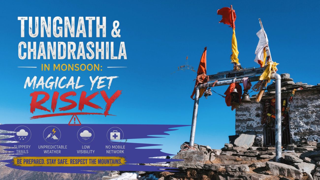
This is the trek to Tungnath & Chandrashila in monsoon—Uttarakhand’s highest Shiva temple to its most deceptive summit. Most blogs romanticize the lush greenery and empty trails. They don’t mention the landslides near Sonprayag, the lightning risk above treeline, or why three trekkers got stuck here in August 2024 because the fog rolled in three hours early.
But here’s the thing: if you respect the mountain, if you pack right, if you go with open eyes—monsoon is when this trek becomes transcendent.
The wildflowers bloom here. The rhododendrons explode in colors you didn’t know existed. The locals say the gods come down during rains. And maybe it’s the altitude talking, but standing in that cloud at Chandrashila, I believed them.
This guide covers everything: the real costs, the actual hazards, the routes most travelers miss, where to stay for ₹800/night without feeling like you’re roughing it, and exactly what day to go if you want a fighting chance at clear skies. I’ve made every mistake on this trek so you won’t have to. Let’s plan this properly.
Why Monsoon Trek to Tungnath Transforms This Peak Into Something Mythical
There’s a reason ancient pilgrims risked this route during rains. The mountain doesn’t look the same when the monsoon hits—it becomes someone else. Someone wilder.
The usual story: Tungnath sits at 3,540 meters, making it India’s highest Shiva temple. Chandrashila, 140 meters higher, is the trekking extension—a rocky summit with 360-degree Himalayan views if the weather cooperates. In summer (April–May), you get crowds: 400–500 people a day on the main Chopta trail, organized groups with matching jackets, the whole Instagram experience.
Then June arrives. Half the trekkers evaporate. The valleys turn emerald green—genuinely electric green, the kind of color that makes your phone camera lie because the real thing’s too intense. Wildflowers colonize the meadows: purple primrose, yellow anemone, pink spiranthes orchids that smell like rain-wet earth and something indefinably ancient.
The risk? Monsoon here isn’t like monsoon in Kerala. You’re at high altitude where weather changes every 90 minutes. Clouds roll in from the Mandakini valley gorge. Fog swallows the trail. Lightning crackles above treeline. The path gets slick—not just wet, but genuinely treacherous near the steep sections below Tungnath temple. I’ve seen experienced trekkers turn back here. Not because of rain, but because visibility dropped to 15 feet and the wind started gusting hard enough to unbalance you on narrow sections.
The honest truth: Monsoon monsoon (July–August) is genuinely risky. Late monsoon (early September) offers the best risk-reward balance. The rains taper off, the valleys stay green, and you get 70% of the beauty with 40% of the danger.
Here’s what the mountain offers in return:
- Solitude: You’ll pass maybe 30 trekkers total. On Chandrashila itself, often just you and the clouds.
- Spiritual atmosphere: The temple feels alive during monsoon—the bells sound different when there’s mist pressing against the walls. Local pilgrim groups come for darshan specifically in monsoon. There’s something about that energy.
- Photography that’ll haunt you: If you catch clear morning light before the fog rolls in (roughly 6:30–8:30 AM on good days), the photos are unreal. Wet grass glowing gold. Distant peaks emerging from clouds. This is what those nature photographers mean when they talk about “magical light.”
- Wildflower trekking: Mid-July through August, the meadows around Chopta and Deoria Tal bloom like nowhere else I’ve trekked in India.
But here’s the flip side—the part every responsible guide needs to say:
7 Reasons Monsoon Trek to Tungnath Is Riskier (Most People Don’t Know The Real Ones)
This is the “read before you book” section.
1. Trail Becomes a Stream
Water doesn’t roll downhill here—it flows across the trail. The section between Deoria Tal and Tungnath temple (about 4km) has permanent water channels in monsoon. Your feet stay wet for 5+ hours. That sounds minor until your toes go numb and you misstep on wet moss-covered rocks. I’ve twisted ankles here. Good trekkers who know better.
Real risk: Slips, ankle injuries, hypothermia if you get drenched and temps drop (can happen—I’ve seen it drop from 18°C to 8°C in 45 minutes in August).
2. Landslides Are Seasonal, Not Rare
The 8km road from Sonprayag to Chopta (the standard approach) sits on a crumbly Himalayan slope. During active monsoon, small rockslides are predictable. Between 2022–2024, at least 4 major closures happened mid-monsoon. They clear them quickly (within 6–12 hours usually), but if you’re driving through during heavy rain and a slide just happened, you wait.
Real risk: Road closure stranding you at lower altitude, forcing an extra night (usually fine, but messes with plans).
3. Lightning Above 3,500m Is Genuinely Deadly
I’m not being dramatic. Chandrashila sits in the strike zone. In 2019, a trekker was struck near the summit (survived, hospitalized for a week). The ridge is exposed—no trees to ground a strike, just rocks and determined pilgrims. If you hear thunder, you descend immediately. No summiting in thunder. No waiting it out.
Real risk: Death. Not common, but possible. One mistake and you’re gone.
4. Altitude Sickness Hits Harder in Wet/Cold
When you’re wet, cold, and exhausted, your body processes altitude differently. I made this mistake my first time—got soaked near Deoria Tal at 2,600m and developed acute mountain sickness (AMS) by afternoon at 3,200m. Massive headache, nausea, couldn’t focus. I’d been fine at this altitude in summer. The combination of cold + wet + exertion hammers you.
Real risk: HACE (high-altitude cerebral edema), HAPE (pulmonary edema)—both require descent and medical help.
5. Fog Kills Navigation Worse Than You’d Think
The trail is marked, but monsoon fog makes it genuinely confusing. I’ve seen groups miss the main path and end up 200 meters off-trail, which on a slope means scrambling through dense vegetation and loose rocks to get back. It adds hours. It’s exhausting. It’s scary if you’re already tired.
Real risk: Getting lost, night descent (dangerous), missed accommodation, panic on the mountain.
6. Local Water = Giardia If You’re Not Careful
Beautiful glacial streams that look pure? They’re not. I drank from one near Tungnath and spent three days with gastro-intestinal issues later. The cattle herds move through these valleys in monsoon. You can’t see the contamination.
Real risk: Severe diarrhea, dehydration at altitude (really bad combination).
7. Weather Windows Are Tiny
Clear mornings last 2–3 hours, then clouds roll in hard. If you misjudge timing, you summit in fog and see nothing. You’ve busted your body for a view of clouds. It’s not dangerous, but it’s demoralizing as hell.
Real risk: Wasted effort, disappointment, possible need to stay extra night hoping for better weather next morning.
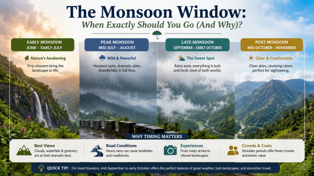
The Monsoon Window: When Exactly Should You Go (And Why)?
Not all monsoon is equal.
June: Early monsoon. Erratic weather. Some days are clear and stunning (I got a perfect June 15th once). Other days, rain starts at 11 AM and never stops. Road conditions are still decent. Crowds are minimal. Verdict: Risky, rewarding if you’re lucky. Go if you’re flexible and can stay 3+ days.
July: Peak monsoon. Heavy rainfall, especially afternoons. Highest cloud cover. Poorest summit visibility. Most landslide risk on roads. Verdict: Only go if you have zero summit expectations and want the wilderness experience. Honestly, skip this month.
August: Late-peak monsoon. Still rainy, but mornings are clearer than July. Rain intensity reduces slightly. Wildflowers are peak. Verdict: Sweet spot. Go first week of August if possible—you get good rain coverage, flowers are still blooming, mornings are clearing up.
Early September (until Sept 10): Late monsoon. Rain reduces significantly. Mornings are mostly clear (70% chance vs 20% in July). Flowers are still there. Roads are stable. Crowds are almost zero. Verdict: Best risk-reward. This is when I go now.
Mid-September onward: Monsoon technically ends, but weather remains unstable. Not quite as beautiful as true monsoon. But definitely safer.
Here’s the thing nobody tells you: Weather forecasting for mountains is near-impossible 5+ days out. What you can do is check:
- IMD (Indian Meteorological Department) 5-day forecast for Uttarkashi district (Tungnath is in Uttarkashi District)
- Windy.com app — zoom to 3,600m altitude level, look at wind patterns and cloud forecasts 5 days out
- Local WhatsApp groups — join Chopta trekking groups, ask about current conditions literally 2–3 days before going
The Trek Itself: Tungnath & Chandrashila Routes, Distances & Real Timings
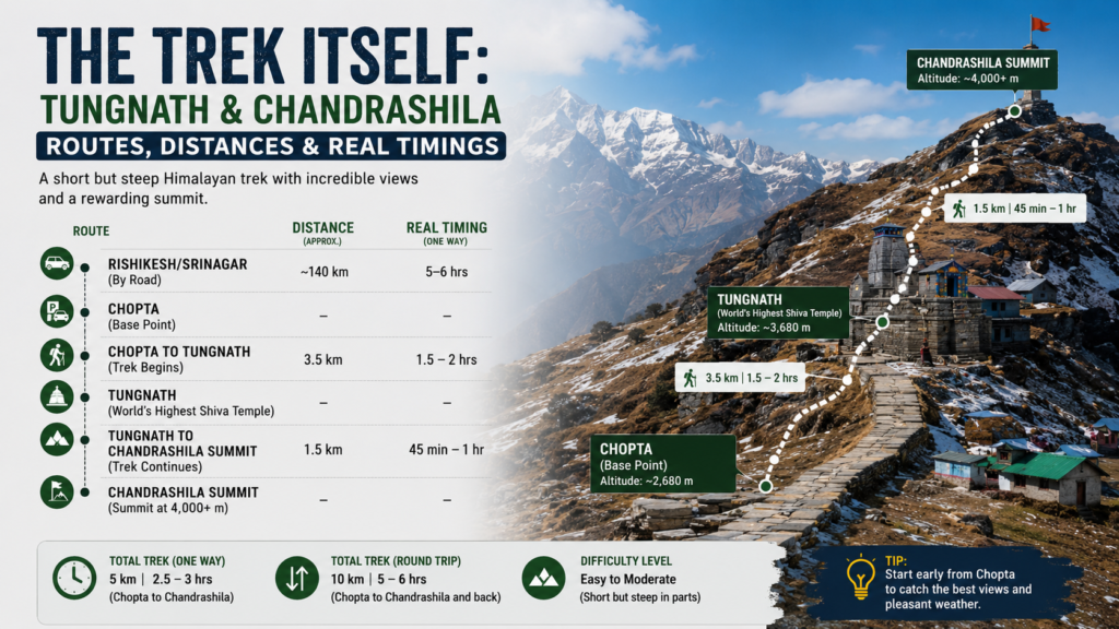
Standard Route: Chopta → Deoria Tal → Tungnath Temple → Chandrashila Summit
This is 99% of trekkers. Here’s the breakdown:
Chopta to Deoria Tal
- Distance: 3.2 km
- Elevation gain: 580m (up to 2,680m from Chopta at 2,100m)
- Time: 2–2.5 hours
- Difficulty: Moderate
- Monsoon specifics: Trail gets muddy, slippery in upper sections. Fog often starts here by 10 AM on cloudy days.
- Sensory detail: Smell the pine change as you rise—crisp at the start, then heavy with damp earth by 2,400m. The forest canopy opens gradually, and you see sky widening above. Deoria Tal itself is gorgeous: a small glacial lake, often mirror-still in early mornings. On clear days, you see Chandrashila reflected perfectly. In monsoon, it’s usually fogged, which honestly makes it more atmospheric—like a Japanese landscape painting.
Deoria Tal to Tungnath Temple
- Distance: 4.1 km
- Elevation gain: 860m (2,680m → 3,540m)
- Time: 3–3.5 hours
- Difficulty: Hard
- Monsoon specifics: This is where it gets serious. Water channels flow across the trail. The sections near Tungnath temple are steep (40–50° angle) and slippery. I’ve seen fit trekkers taking 4 hours here in wet conditions. The rhododendron forests are dense—in monsoon, they drip constantly, soaking you even when it’s not actively raining.
- Sensory detail: Your thighs burn. The air gets colder and damper. At 3,200m, you might start feeling altitude—slight breathlessness, mild headache. The temple appears suddenly through the mist, bells clanging in the wind. The smell of the temple hits before you see it: sandalwood incense mixing with wet stone and pine smoke from the kitchen.
Tungnath Temple to Chandrashila Summit
- Distance: 1.9 km
- Elevation gain: 140m (3,540m → 3,680m)
- Time: 1–1.5 hours up, 45 min down
- Difficulty: Hard (exposed ridge, altitude, weather exposure)
- Monsoon specifics: This final push is where weather usually deteriorates. Wind gusts pick up. Visibility can drop from 500m to 30m in 10 minutes. The trail is rocky, sometimes icy even in monsoon (cloud mist freezes on rocks above 3,600m). The summit itself has a small stone shrine. In fog, you see 10 meters. On rare clear days, you see all the way to Nepal—Nanda Devi, Trishul, Chaukhamba peaks lined up like gods at a gathering.
Pro tip: Don’t summit if there’s active lightning, even distant. The ridge is a lightning rod. Descend immediately. The summit will be there on the next clear day—probably tomorrow or the day after.
Alternative: Tungnath via Chopta Road Walk
Some people drive closer to Tungnath temple (via the Chopta-Sonprayag road, which goes partway up), starting the trek closer to the temple. This cuts 2–3 hours off total time. Downside: You miss Deoria Tal (one of the prettiest parts), you don’t acclimatize as well, and the 4WD road in monsoon is rough—we’re talking rough. Not recommended in active monsoon.
Lesser-Known Route: Auli → Tungnath (3-Day Trek)
Most tourists don’t know Auli (2 hours from Chopta) connects to Tungnath via a less-traveled high-altitude route. It’s harder, longer, and gorgeous. You trek through high meadows, see fewer people, acclimatize better. Takes 2 full days to reach Tungnath, sleep there, and summit Chandrashila on day 3.
My honest take: Do the standard Chopta route. It’s popular for a reason. The alternative routes are nice but not transformative enough to justify extra risk.
Tungnath Temple: History, Spirituality & What You’ll Actually See
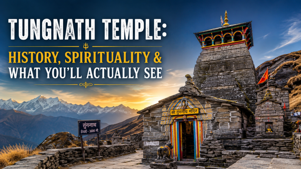
3,540 meters. India’s highest Shiva temple.
The temple’s small—a modest stone structure, maybe 8 meters tall. What strikes you isn’t the size but the presence. This is a working temple, not a tourist site (though tourists visit). The priest lives here year-round. The kitchen operates daily. In monsoon, you might find 20–30 pilgrims here, not tourists. They’re here for darshan, not Instagram.
The history is convoluted: Legend says the Pandavas built this to atone for killing Brahmins in the Mahabharata. Archaeological evidence suggests it’s medieval (12th–13th century). What matters is that people have been climbing this mountain to pray for 800+ years. Your visit is part of that chain.
What to expect:
- The priest will likely let you into the inner sanctum if you’re respectful. No photography inside.
- The bell rings loudly—it echoes in the mountains. Genuinely moving if you’re spiritual.
- There’s a small donation box. ₹101–501 is standard.
- The view from the temple courtyard is stunning if weather cooperates. You see the Mandakini valley, Kedarnath Wildlife Sanctuary ridges, and on clear days, distant Kanchenjunga (the easternmost Himalayan giant).
- The priest’s chai is exceptional. Accept the offer. Pay ₹50 per cup.
- In monsoon, the temple can feel mysterious—the fog pressing against walls, the silence inside broken only by bells and water dripping from the roof.
One etiquette thing: Temple photography rules are strict here. No shoes past the courtyard. No loud talking. No phone calls inside. The locals are respectful, and the energy is different from popular temples. Behave accordingly.
Chandrashila Peak: The Honest View (Literal & Metaphorical)
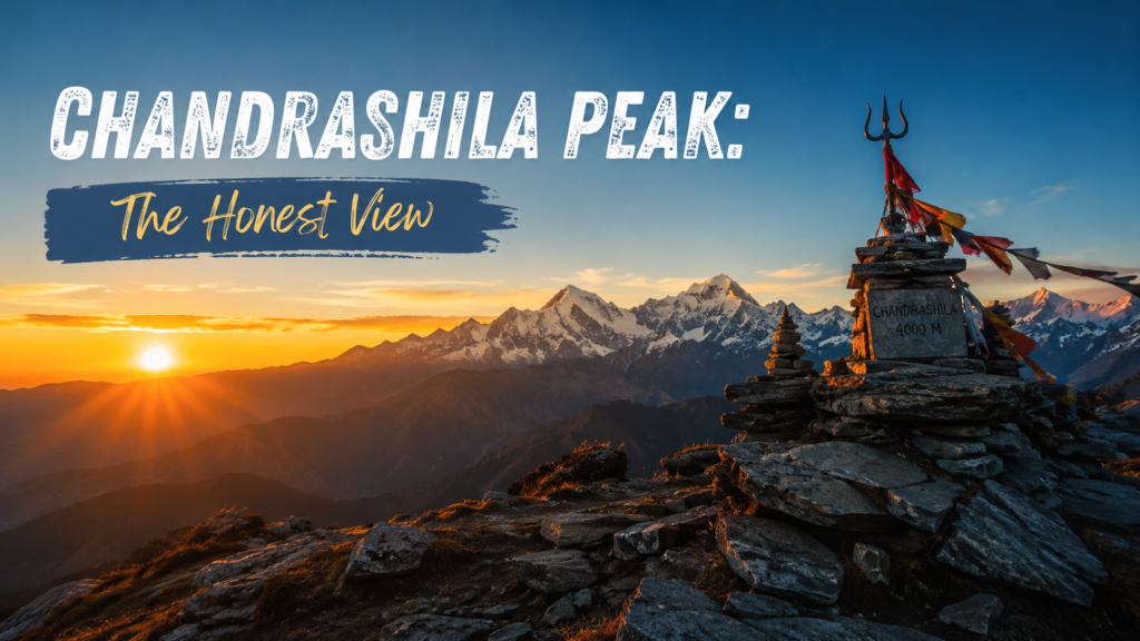
The final 1.9 km feels longer than it is. You’re at 3,540m already, oxygen is thinner, your legs know they’ve already climbed 1,400+ meters today.
The ridge narrows. One side drops steeply toward Mandakini valley. The rocks get bigger and more exposed. In monsoon, they’re damp. Wind picks up—gusts that actually stagger you if you’re not paying attention.
And then the summit. A rocky outcrop. A small shrine. A cairn of stones from a thousand previous trekkers.
Here’s the brutal honesty about the view:
- On clear days: 360° Himalayan panorama. Nanda Devi massif to the east. Chaukhamba to the south. Kedarnath to the west. The scale is incomprehensible—you’re standing on top of the world.
- In fog (which is 60–70% of monsoon days): You see 30–50 meters. Grey. Quiet. Slightly eerie.
Both are worth it, honestly. The fog version is melancholic and meditative. The clear version is spiritual in a different way—awe instead of introspection.
The thing that gets me: Sitting on the summit in fog, I’ve never felt more alone. Not lonely—alone in the cleansing way. Like the mountain dissolves your everyday problems by making you so small and insignificant that they don’t matter.
Best Time for Clear Weather: Reading the Monsoon Calendar
I’ve already mentioned this, but here’s the tactical stuff:
If you want 70% chance of clear morning: Early September (Sept 1–7)
If you want peak wildflowers + decent weather: Late August (Aug 20–31)
If you want solitude above all: Mid-July (least crowded, worst weather, makes for memorable stories later)
If you want fewest landslides: Early June or after Sept 10
The 48-hour rule: Don’t book accommodation more than 48 hours in advance during monsoon. Book your trek 48 hours before based on IMD forecast. This means staying in Chopta and waiting, but you get to make the call based on actual weather data, not hopes.
How to Reach Tungnath: 3 Routes, Real Costs & Road Conditions
Route 1: Delhi → Chopta (Recommended)
Distance: ~365 km (Delhi to Chopta)
Drive Time: 9–10 hours non-stop (not recommended—break into 2 days)
Route: Delhi → Meerut → Haridwar → Rishikesh → Narendra Nagar → Srinagar → Gairsain → Chopta
Drive Quality: National highway (NH119/NH309) until Srinagar (Uttarakhand), then state roads. Roads are decent but narrow in sections. Monsoon makes them slippery—expect some rock/landslide debris.
Cost Breakdown (Personal Car):
- Petrol/Diesel: ~₹2,500–3,000
- Toll (Meerut–Haridwar): ~₹250
- Parking in Chopta: ₹100–200/day
By Bus:
- UKTBC (Uttarakhand Transport) and private operators run Delhi → Chopta buses. ₹1,200–1,800 one-way.
- Journey time: 12–14 hours (frequent stops).
- Book via uttarakhandtourism.gov.in or eTravelSmart.
Pro tip: Split the drive. Stay in Haridwar (1.5 hours from Delhi, ₹600–1,200 budget hotel) or Srinagar (Uttarakhand—not Kashmir, easier drive next morning). This breaks up the grind and helps acclimatization (you gradually gain altitude vs. a brutal push).
Route 2: Delhi → Auli → Chopta (Scenic, Longer)
Distance: ~380 km
Drive Time: 10–11 hours
Route: Delhi → Haridwar → Rishikesh → Srinagar → Auli → Joshimath → Gairsain → Chopta
Why Auli? It’s at 3,000 meters—the highest ski resort in Asia. You acclimate partially before trekking. The views are stunning. The detour adds 1–2 hours but changes the whole trip energy.
Cost: Same petrol cost, but Auli road is scenic, slightly slower (more curves). Gas stations are fewer after Joshimath—fuel up there.
Where to stay in Auli: GMVN Tourist Rest House (₹1,500–3,000/night), or private resorts (₹3,000–8,000). Honestly, skip unless you have time. Chopta is more practical.
Route 3: Dehradun → Chopta (Fastest)
Distance: ~195 km
Drive Time: 5–6 hours
Route: Dehradun → Mussoorie → Chopta (scenic highway, mostly good roads)
Fly into Delhi, train/bus to Dehradun: Multiple direct trains from Delhi to Dehradun (5–6 hours, ₹300–800). Then this route is fastest.
Cost: ₹1,500–2,000 petrol, ₹100 toll.
Road Quality: Excellent until Chopta approach, then narrow/rough near Sonprayag in monsoon.
Nearest Airports & Connectivity
- Indira Gandhi International (Delhi): 365 km from Chopta (9–10 hours drive)
- Jolly Grant (Dehradun): 195 km from Chopta (5–6 hours drive)
- Pantnagar: 220 km, rarely used
Flight + Drive: Fly to Dehradun, hire a taxi (₹3,500–5,000 for full day, shared ₹400–800 per seat). Split with other trekkers.
Trains
- Delhi → Dehradun: Shatabdi Express (2255, 3:00 PM arrival), Mussoorie Express (9015, 5-hour journey). Prices: ₹600–1,200.
- Dehradun → Chopta: No direct train. Taxi/bus from Dehradun.
Road Condition Reality Check (Monsoon)
I’m being honest here:
- June–July: Expect at least one small blockage every 3–4 trips (landslides, debris). Usually cleared within 6 hours.
- August: Better. Fewer blockages, but still possible.
- Early September: Cleanest roads. Best driving conditions.
BSNL works best on this route. Jio drops frequently between Srinagar and Gairsain. Download offline Google Maps of the Chopta–Sonprayag section before leaving cellular range.
Where to Stay: Budget to Premium Options (With Real Names & Prices)
Budget (<₹1,500/night)
The Wanderer’s Nest, Chopta
- ₹800–1,200 double room, dorm ₹400
- Basic but clean. The owner is helpful. No frills, but great views from the attached café.
GMVN Tourist Rest House, Chopta
- ₹1,200–1,500 rooms
- Government-run. Basic facilities. Decent kitchen. Slow service but reliable.
- Booking: gmvn.in
Homestays (₹600–1,000): Check uttarastays.com for local family homestays. You get home-cooked Garhwali food (buckwheat rotis, mandua ki roti, ghee-laden curries). Prices vary, often negotiable.
Mid-Range (₹1,500–4,000)
Kosi Valley Organic Farm, Chopta
- ₹2,000–3,000
- Organic farm setting. Vegetarian food. Lovely hosts. Small rooms but cozy.
- Contact: Facebook page “Kosi Valley Organic”
Jugni’s Nest, Chopta
- ₹1,800–2,800
- Boutique homestay. Exceptional food. The owner (Jugni) is a former trekker.
- Booking: Direct contact or Wandertrails.com
Chopta Alpine Resort
- ₹2,500–3,500
- Better amenities, restaurant on-site, some rooms with views.
- Booking: Online portals or direct
Premium (₹4,000+)
Auli by GMVN / Chopta by GMVN Premium Cottages
- ₹5,000–8,000
- Heated rooms, decent restaurants, reliable service.
- Booking: gmvn.in
Private resorts: Limited options in Chopta itself. Most premium stays are in Auli (50 km away, scenic but adds drive time).
Where I’d Stay
Honestly? Jugni’s Nest. The food is exceptional (Jugni makes momos and local dishes that rival restaurants 10x the price), the owner understands trekker needs, and it’s ₹2,000 for a double. Book it if you can.
For budget + reliability: GMVN Rest House. You get government-standard service, decent rooms, and zero drama.
What to Eat: 7 Garhwali Dishes + Where to Find Them
The food here is wheat and lentil focused—carbs for high-altitude trekking, basically.
1. Buckwheat Rotis (Kuttu Ki Roti)
- Thin, slightly crispy flatbreads. Earthy flavor, nutty undertones.
- Where: Every homestay, local dhaba between Chopta and Sonprayag
- Cost: ₹20–50 per roti
- Eat with: Ghee and locally-made paneer. Perfect pre-trek fuel.
2. Mandua (Finger Millet) Porridge
- Greyish, thick porridge with a slight bitterness. Sounds unappealing, tastes incredible with jaggery and ghee.
- Where: Homestays, breakfast at Kosi Valley
- Cost: ₹100–150 per bowl
- Nutritionally: packed with minerals. Better altitude acclimatization food than pasta.
3. Aloo Ke Parathas
- Potatoes stuffed into wheat dough, fried on griddle. Crispy edges, soft inside.
- Where: Every dhaba
- Cost: ₹60–100
- Best eaten after trekking. Heavy, satisfying, refuels glycogen stores.
4. Pulses with Local Greens (Dals)
- Lentil curries with foraged leafy greens. Tastes like iron and earth in the best way.
- Where: Homestays
- Cost: ₹80–120 per plate
- Great for altitude sickness prevention (iron + mineral-rich).
5. Garhwali Chutneys
- Mint-cilantro-green chili (fresh, pungent, clears sinuses), or tomato-based.
- Where: Everywhere
- Cost: Free with meals, or ₹20 standalone
- Seriously underrated. Amazing taste.
6. Milk Tea (Doodh Chai)
- Milk-heavy tea with cardamom, often ginger. The tea at Tungnath temple priest’s kitchen is exceptional.
- Where: Every café, temple
- Cost: ₹20–50
- Sip slowly. High altitude + hot liquid = hydration + warmth.
7. Besan Laddoos (Chickpea Flour Sweets)
- Round, golden sweets. Melt-in-mouth. Slightly nutty.
- Where: Local shops in Chopta, Gairsain
- Cost: ₹150–200 per kg
- High-calorie energy food. Pack some for the trek.
What to Pack: Monsoon-Specific Gear List
This isn’t a generic packing list. This is what you actually need for monsoon at 3,600m.
Upper Body
- Thermal layer top: Merino wool or synthetic. Cotton = death in wet, cold conditions. ₹800–1,500
- Fleece jacket: Lightweight, breathable. ₹1,200–2,000
- Windproof outer jacket: Critical. Rain jacket + windproof in one. Gore-Tex recommended. ₹2,500–5,000
- Quick-dry long-sleeve shirt: Protects from sun (altitude = stronger UV) and insects.
Lower Body
- Trekking pants: Quick-dry. NOT jeans (stay wet forever). ₹1,500–2,500
- Thermal leggings: Under your pants. ₹600–1,200
- Change of dry pants: For evening.
Feet (Critical)
- Waterproof trekking boots: Ankle support is non-negotiable on slippery monsoon trails. Must be broken in before trek. ₹3,500–6,000
- Wool socks: 3–4 pairs. Moisture-wicking synthetic blends work. ₹200–400/pair
- Gaiters: Prevent water + mud from entering boots from the top. ₹400–800
- Separate dry socks for evening.
Head, Hands, Extras
- Beanie/wool cap: You lose 40% of body heat through head. Non-negotiable.
- Waterproof gloves: Monsoon winds are cold. Fingers go numb fast.
- Hat with brim: For daytime sun protection.
- Scarf/neck gaiter: Wind protection at summit.
Backpack & Protection
- 50L backpack with rain cover (or internal waterproof liner).
- Dry bags: Multiple small ones. Everything goes wet eventually. Keep essentials dry.
- Waterproof stuff sacks: ₹200–400 for 3–4.
Hydration & Nutrition
- 2L water bottle: Liters. Not cups.
- Electrolyte salts: ORS packets, or Liquid IV. Altitude dehydration is real.
- High-calorie snacks: Nuts (₹300/100g), chocolate (₹50–100), energy bars (₹100–150), jaggery with ghee (₹50).
- Trail mix: Pre-pack. ₹200–300 for trek duration.
- Glucose powder: For emergency energy boost.
Safety & Medical
- Basic first aid kit: Band-aids, antiseptic, painkillers (ibuprofen), anti-diarrheal (Imodium), anti-nausea (domperidone).
- Altitude sickness meds: Acetazolamide (Diamox) prescribed by doctor before trek. Takes 48 hours to work—start 2 days before.
- Blister treatment: Leukoplast tape. Blisters at high altitude are dangerous (can get infected).
- Sunscreen: SPF 50+. ₹400–800. Altitude = stronger UV.
- Lip balm: With SPF.
Navigation & Communication
- Offline Google Maps downloaded (Chopta + Tungnath area).
- Phone powerbank: ₹1,000–2,000. BSNL phone works best.
- Headlamp: For early starts or emergency descent. LED, 100+ lumens.
- Whistle: Emergency signal.
Miscellaneous
- Trekking poles: Reduces knee impact on descent. ₹1,500–3,000.
- Toilet paper + waste bags: Pack out all waste.
- Camp soap + shampoo: Biodegradable brands.
- Insect repellent: Monsoon = bugs. ₹200–400.
- Spare battery: For camera/phone.
- Notebook + pen: For journaling (trust me, you’ll want to).
Total Packing Cost: ₹12,000–20,000 if buying new. Borrow/rent what you can.
Travel Tips: Monsoon-Specific, Not Generic Nonsense
1. BSNL SIM + JIO Backup
Get a BSNL sim if you don’t have one. BSNL actually works better at high altitude in Uttarakhand (weird but true—something about tower placement). Jio drops past 3,200m. But have both.
2. Hire a Local Guide for First Trek
₹1,000–1,500 for full day (Chopta → Tungnath → Chandrashila). Worth it for: route clarity, weather reading, altitude sickness monitoring, emergency contact. WhatsApp “Chopta trekking guides” into any Uttarakhand group—locals respond within hours.
3. Altitude Sickness Isn’t Weakness
I’ve seen ultra-fit gym-goers vomit at 3,400m while couch potatoes sail through. It’s genetic. If you get headache + nausea, descend immediately. No shame. The mountain will be there next week.
4. Carry Cash. Lots of It.
ATMs in Chopta work 60% of the time. No card payments above Chopta. Bring ₹5,000 minimum in cash (guides, tips, emergency shelter, food).
5. Water Above Sonprayag Isn’t Safe
Streams are contaminated. Boil it 5+ minutes or use purification tablets (₹200 for 100 tablets). The lake at Deoria Tal looks pristine—it’s not.
6. Temple Photography Rules
No photos inside Tungnath temple sanctum. Outside and courtyard photos are fine. Flash irritates the priest. Be respectful.
7. Lightning Safety Isn’t Optional
Hear thunder = descend. I don’t care if you’re 10 minutes from summit. Lightning at 3,600m kills. Not maybe. Kills. One strike, one death.
8. Download IMD Forecast
mausam.imd.gov.in has Uttarkashi district 5-day forecast. Check the evening before your trek. If it says “heavy rainfall” and “thunderstorms,” reschedule.
9. Acclimatize: Sleep Low, Trek High
Spend night in Chopta (2,100m) before trekking. Your body needs 6–8 hours to start acclimatizing. Don’t drive from Dehradun and summit Chandrashila same day (I see this every season—people get HACE).
10. The Priest at Tungnath Is Your Friend
If you get stuck (weather, injury, exhaustion), the priest has radio contact with Sonprayag. He’s helped countless trekkers. Be respectful. Donate to the temple.
11. Biodiversity Awareness
This is Kedarnath Wildlife Sanctuary. Musk deer, Himalayan bears, and snow leopards (rare) live here. Make noise while trekking (so you don’t startle bears). If you see wildlife, back away slowly. Don’t take selfies.
12. Monsoon Blooming Wildflowers
July–August, the meadows between Chopta and Deoria Tal explode in wildflowers. Don’t pick them. Photograph only. These are rare high-altitude species.
4-Day Sample Itinerary: The Safe, Scenic Route
| Day | Morning | Afternoon | Evening | Stay |
|---|---|---|---|---|
| Day 1 | Travel from Delhi/Dehradun (early start, 8 AM). Arrive Chopta by 5 PM. Rest, acclimatize. | Settle into accommodation. Buy groceries in Chopta town (near bus stand). Charge devices. | Light walk around Chopta village (1 km). Explore GMVN rest house or homestay. Early dinner (7 PM). Sleep by 9:30 PM. | Chopta (GMVN or Jugni’s Nest) |
| Day 2 (Trek Day 1) | 5:30 AM start. Light breakfast: oatmeal, banana, chai. | Trek: Chopta → Deoria Tal (3.2 km, 2.5 hrs). Rest 30 min. Explore lake. Return to Chopta by 1 PM. Lunch. | Afternoon nap. Light stretching. Hydrate heavily. Dinner: high-carb (aloo parathas). Sleep early. | Chopta (same place) |
| Day 3 (Trek Day 2) | 4:30 AM start. Pre-trek meal at 4 AM. Leave 5:15 AM. | Chopta → Deoria Tal (2.5 hrs) → Tungnath Temple (3.5 hrs = 6 hours total). Lunch at temple if available (priest’s kitchen). Rest. | Acclimatize rest. Explore temple courtyard. Chai with priest. Light dinner. Early sleep. | Tungnath Temple Guesthouse (₹400–800, basic but functional) or return to Chopta if too tired |
| Day 4 (Summit Day) | 4:00 AM start. Empty stomach ok (light snack: 1 banana). | Tungnath Temple → Chandrashila Summit (1.9 km, 1.5 hrs up). Reach ~5:45 AM (if clear). Summit 6–7 AM for sunrise. Descend by 9 AM if fogged in. Lunch at temple. | Afternoon: Descend Tungnath to Deoria Tal (4 hrs total). | Chopta or Deoria Tal lodge |
| Day 5 | Return to Dehradun/Delhi (early start, 8 AM). Arrive by 5 PM. | — | — | Home |
Pro Upgrade: Extend to 5-day trek. Add a night at Deoria Tal (basic lodge available) to break up the descent. Less exhausting.
Express 2-Day Version (Weekend Warriors):
- Day 1: Dehradun → Chopta (arrive 12 PM) → Trek Chopta to Deoria Tal afternoon (3–4 PM). Stay Chopta.
- Day 2: 4:30 AM start. Deoria Tal → Tungnath → Chandrashila → Deoria Tal → Chopta. Massive day (10+ hours). Not recommended in monsoon, but possible if weather is exceptional.
Real Cost Breakdown: Budget to Premium (2026 Pricing)
| Expense Category | Budget (₹) | Mid-Range (₹) | Premium (₹) |
|---|---|---|---|
| Transport: Delhi to Chopta (round-trip) | 1,800 (bus) | 4,000 (taxi shared) | 7,000 (private taxi) |
| Transport: Dehradun to Chopta (round-trip) | 1,200 (bus) | 2,500 (shared auto) | 5,000 (private cab) |
| Accommodation Chopta/Trek Sites/night | 600–1,200 | 1,500–2,500 | 4,000–6,000 |
| Food per day (3 meals + snacks) | 300–500 | 600–1,000 | 1,500–2,000 |
| Guide hire (full day) | 1,000 | 1,200 | 1,500 |
| Trek permits/entry fees | 0 | 0 | 0 |
| Gear rental (if not owned): boots, jacket, etc. | 500 | 0 | 0 |
| Emergency medical/contingency | 500 | 1,000 | 1,000 |
| Miscellaneous (tips, chai, temple donation) | 400 | 600 | 1,000 |
| TOTAL (4 days, budget range) | ₹6,700–8,500 | ₹11,900–15,000 | ₹21,000–27,500 |
Real talk:
- Budget travelers: Spend ₹7,500–10,000 including train/bus from Delhi, and get an excellent experience.
- Mid-range: ₹12,000–18,000 includes comfort + some luxury (good hotel, guided trek, better food).
- Premium: ₹22,000+ = 5-star hotels in Auli, private guides, premium meals. Honestly not necessary for this trek.
FAQs: Most Asked Questions on Tungnath & Chandrashila in Monsoon
Is Tungnath & Chandrashila in monsoon trek, safe for solo female travelers?
Yes, with caveats. The trek is well-traveled—you’ll pass other groups. Hire a guide (non-negotiable for first-timers). Physically, it’s not harder for women. Socially: Uttarakhand is safe. The locals are respectful. I know dozens of solo women who’ve done this trek. The biggest risk is altitude sickness (affects everyone equally), not harassment.
How long is the actual trek from Chopta to Chandrashila and back?
Full round-trip from Chopta: 8–10 hours for fit trekkers, 10–12 hours for moderate fitness. This is: Chopta → Deoria Tal (2.5 hrs up) → Tungnath (3.5 hrs up from Deoria) → Chandrashila (1.5 hrs up) → Reverse descent (5–6 hrs total). Most people split this into 2 days: Day 1 = Chopta to Deoria Tal and return; Day 2 = Chopta to Chandrashila summit and return.
What’s the altitude of Chandrashila peak and does it cause altitude sickness?
3,680 meters (12,073 feet). Altitude sickness risk is moderate. You’ve gone from sea level to 3,680m in roughly 24 hours, which is fast. Symptoms: headache, nausea, dizziness, shortness of breath. Severe: confusion, ataxia (loss of balance). Prevention: ascend slowly, hydrate (3+ liters/day), eat carbs, consider Diamox if you’re prone to AMS. If symptoms persist above 3,200m, descend immediately. It works.
Can complete beginners trek Tungnath in monsoon?
Yes, if “beginner” means “doesn’t hike regularly but is generally fit.” If “beginner” means “couch to Chandrashila,” no. The trek is technically non-technical (no rock climbing), but it’s steep, long, and at high altitude. Do these before attempting Tungnath: 3–4 moderate day-hikes (10–15 km) at lower altitude in the months prior. Get fit beforehand.
What’s the best month to trek Tungnath in monsoon season?
Early September (Sept 1–7). This is when you get 70% of monsoon beauty (green valleys, wildflowers) with 40% of the danger (clearer mornings, fewer landslides). Late August (20–31) is the close second. Avoid July entirely unless you have zero summit expectations and want a wilderness meditation retreat.
How do I prevent altitude sickness before reaching Chopta?
Start Diamox (acetazolamide) 48 hours before arriving at Chopta. Dose: 250 mg twice daily (prescription required). Start hydration 2–3 days before trek. Avoid alcohol and sleeping pills. Spend night at lower altitude (Chopta is 2,100m) before going higher. Eat carbs, not heavy fats (easier digestion at altitude). If you have history of AMS, consult a doctor before taking Diamox—there are alternatives (ginkgo biloba, though less proven).
What’s the difference between Tungnath and other high-altitude temples in Uttarakhand (Kedarnath, etc.)?
Altitude: Tungnath is 3,540m (highest Shiva temple, period). Kedarnath is 3,584m but involves a tougher trek and higher altitude. Tungnath is more accessible.
Difficulty: Tungnath → Chandrashila is a day-trek. Kedarnath requires 3–4 days minimum and is more crowded (500+ pilgrims daily in summer).
Spiritual vibe: Tungnath feels more remote. Fewer people. More intimate. Kedarnath is grander but busier.
My take: Tungnath > Kedarnath for solo trekkers or small groups seeking solitude. Kedarnath if you want the “grand Yatra” experience.
Is there a monsoon road closure that might prevent access to Chopta?
Probably not complete closure, but partial blockages are common (50% chance in July, 20% in August, 10% in Sept). They’re usually cleared within 6–12 hours. Rarely, heavy slides can close roads for 24+ hours. If you’re on a tight schedule, build in a 1–2 day buffer. If you’re flexible, monsoon road closures add to the adventure narrative later.
Conclusion: Why This Trek Matters Right Now
Standing on Chandrashila in September rain, with clouds pressing against the summit, I realized something: this isn’t a trophy trek. You don’t come here for the Instagram photo (though you might get lucky). You come here because the mountain demands respect, asks you to be better equipped, more aware, more humble than summer tourists.
Monsoon transforms Tungnath from a “popular pilgrimage site” into something older—something the locals know is sacred precisely because it’s dangerous. The pilgrims who come in monsoon aren’t here for the view. They’re here for the prayer. And maybe that’s what the mountain rewards.
2026 is shaping up to be exceptional for monsoon trekking here. The new road up to Chopta is finally improving (should be complete by June). The GMVN is upgrading facilities at Tungnath guesthouse. And more importantly, more trekkers are booking monsoon because they’re getting wise to the beauty others miss.
If you’re reading this and thinking, “I want to try this,” here’s what I’d do:
- Pick early September (Sept 1–7). Check IMD forecast 5 days before.
- Book accommodation in Chopta first. I’d stay at Jugni’s Nest or GMVN.
- Hire a guide (₹1,000–1,200) through local WhatsApp groups.
- Bring actual gear—not just enthusiasm.
- Respect the mountain. Lightning isn’t brave. It’s just dying at 3,680 meters.
The trek isn’t about conquering anything. It’s about being present in a place where presence is all you have.
Ready to plan? Explore uttarakhand.tours for homestay bookings, guide introductions, and deeper regional guides. Share this with someone you’d want on this trek. And come back here after you summit—I want to know what the clouds showed you.